
International
ADVANCED AND APPLIED SCIENCES
EISSN: 2313-3724, Print ISSN: 2313-626X
Frequency: 12
![]()
Volume 11, Issue 7 (July 2024), Pages: 11-18

----------------------------------------------
Original Research Paper
USG matrix analysis and power interest to improve community environmental awareness: A case study of mangrove land cover to support community and environmental education
Author(s):
Affiliation(s):
1Department of Biology Education, Universitas Sultan Ageng Tirtayasa, Serang, Indonesia
2Center for Geospatial Research, Badan Riset Dan Inovasi Nasional, Jakarta, Indonesia
3Department of Electrical Engineering, Universitas Sultan Ageng Tirtayasa, Cilegon, Indonesia
Full text

* Corresponding Author.
 Corresponding author's ORCID profile: https://orcid.org/0009-0009-1756-1617
Digital Object Identifier (DOI)
https://doi.org/10.21833/ijaas.2024.07.002
Abstract
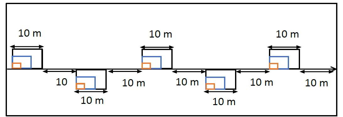
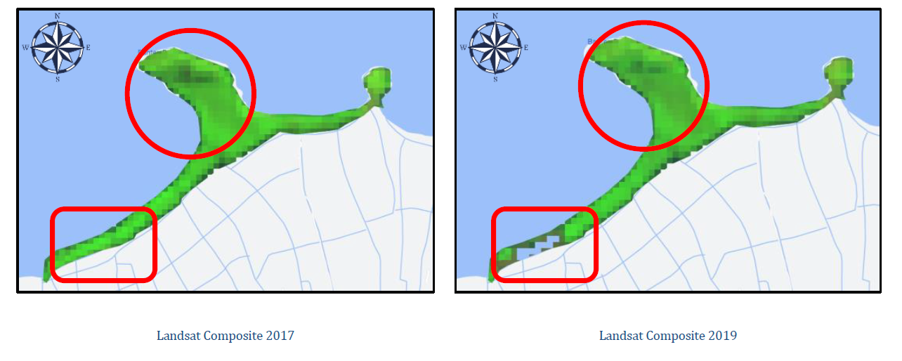
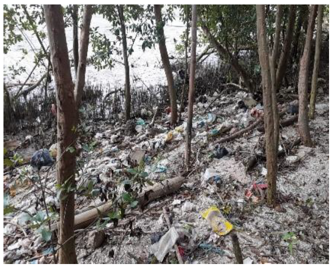
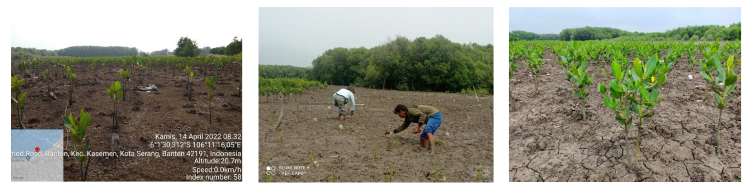
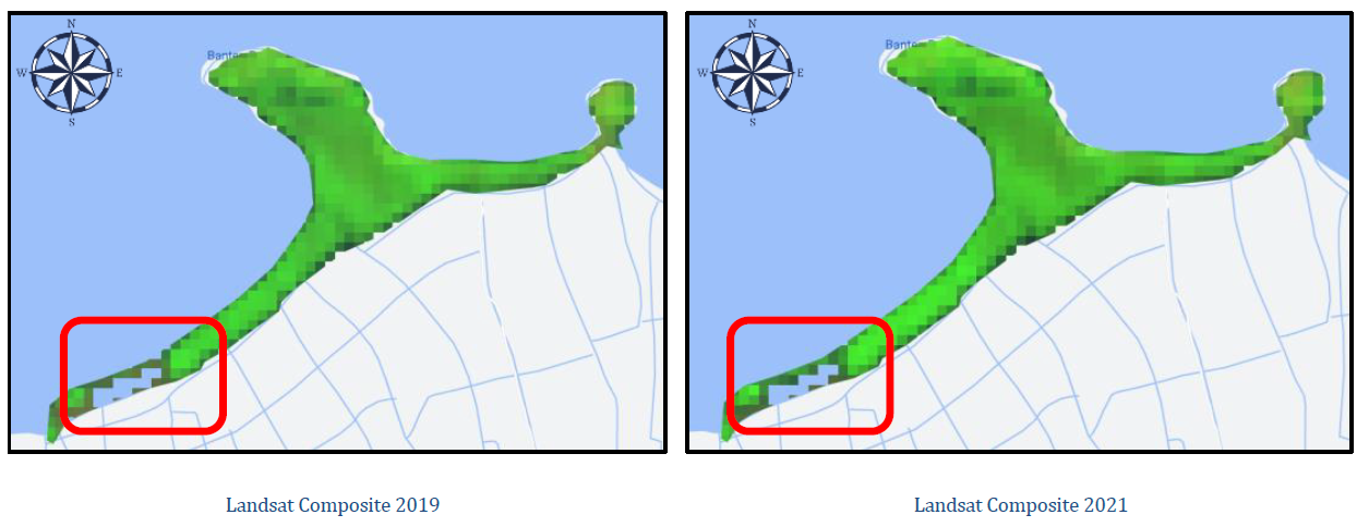
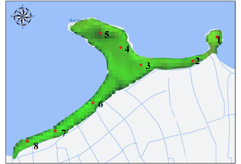
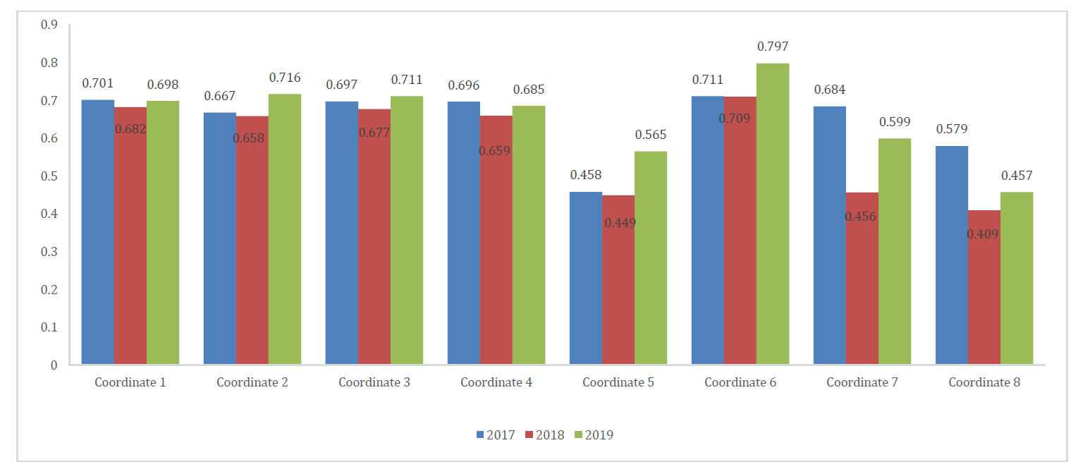
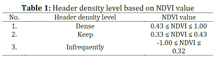
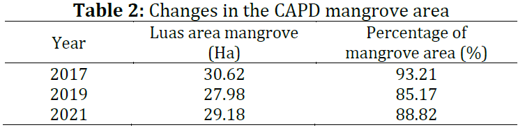
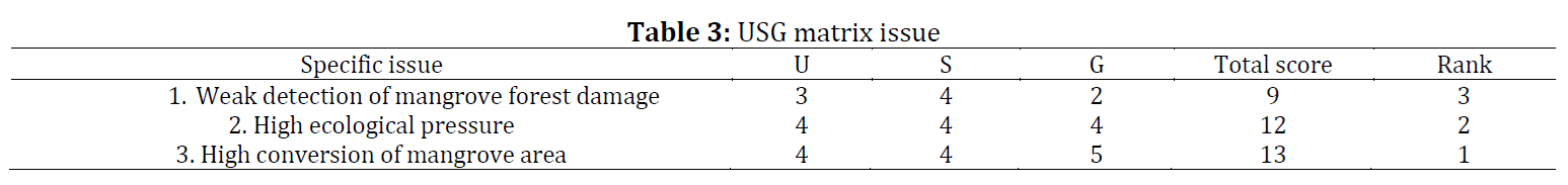
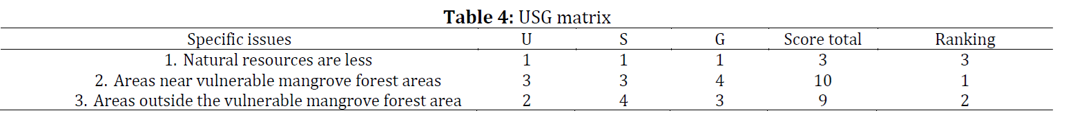
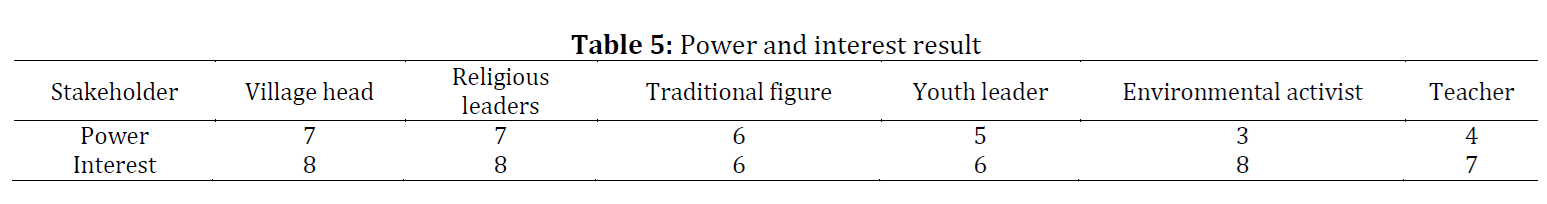
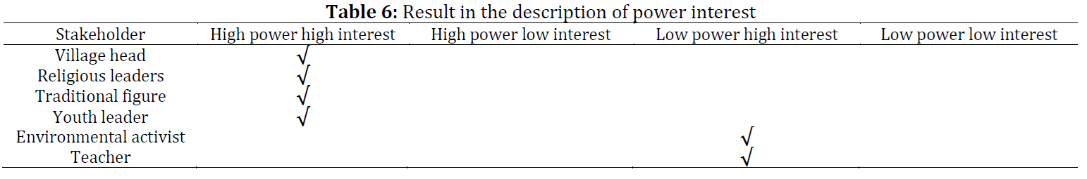
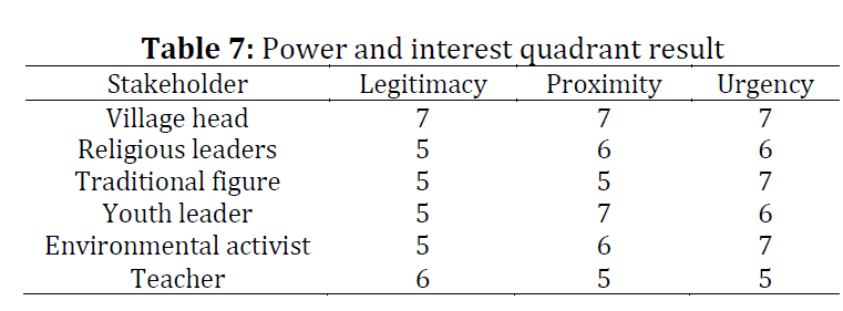
This study employed a mixed-method approach to analyze the composition of mangrove forests. The transect method and remote sensing through supervised classification using Google Earth Engine (GEE) were utilized to assess changes in mangrove areas in 2017, 2019, and 2021. The findings suggest that this study should be included in population and environmental education courses. The results revealed that Avicennia marina mangroves had the highest importance index (INP) values at three different locations. Between 2017 and 2019, mangrove areas decreased from 30.62 hectares to 27.98 hectares. However, from 2019 to 2021, the mangrove area increased from 27.98 hectares to 29.18 hectares, largely due to reforestation efforts in the Pulau Dua Nature Reserve. The NDVI (Normalized Difference Vegetation Index) values indicated "bushy" criteria, ranging from 0.43 to 1.00. The Normalized Difference Mangrove Index (NDMI) values fell into the "Rare" (-1.00 to 0.32) and "Medium" (0.33 to 0.43) categories. The Urgency, Seriousness, and Growth (USG) matrix analysis and Power Interest assessment identified illegal logging, erosion, and waste as significant causes of mangrove decline. Stakeholders, including village chiefs, religious leaders, traditional leaders, and youth leaders, must focus on preserving the mangrove ecosystem in the CAPD. The study's results are vital for educational purposes, particularly in population and environmental education courses. These courses should address environmental issues, prevention strategies, and conservation activities, which can be integrated into the curriculum. This will enable youth to contribute effectively to environmental awareness programs.
© 2024 The Authors. Published by IASE.
This is an
Keywords
Mangrove forest composition, Remote sensing, Google Earth engine, Reforestation activities, Environmental education
Article history
Received 21 July 2023, Received in revised form 27 February 2024, Accepted 15 June 2024
Acknowledgment
No Acknowledgment.
Compliance with ethical standards
Conflict of interest: The author(s) declared no potential conflicts of interest with respect to the research, authorship, and/or publication of this article.
Citation:
Utari E, Herlyn H, Mahrawi M, Sanjaya H, and Santoso MI (2024). USG matrix analysis and power interest to improve community environmental awareness: A case study of mangrove land cover to support community and environmental education. International Journal of Advanced and Applied Sciences, 11(7): 11-18
Figures
Fig. 1 Fig. 2 Fig. 3 Fig. 4 Fig. 5 Fig. 6 Fig. 7 Fig. 8
Tables
Table 1 Table 2 Table 3 Table 4 Table 5 Table 6 Table 7
----------------------------------------------
References (32)
- AlQahtany AM, Dano UL, Elhadi Abdalla EM, Mohammed WE, Abubakar IR, Al-Gehlani WAG, and Alshammari MS (2022). Land reclamation in a coastal metropolis of Saudi Arabia: Environmental sustainability implications. Water, 14(16): 2546. https://doi.org/10.3390/w14162546 [Google Scholar]
- Anurogo W, Lubis MZ, Khakhim N, Prihantarto WJ, and Cannagia LR (2018). Pengaruh pasang surut terhadap dinamika perubahan hutan mangrove di kawasan Teluk Banten. Jurnal Kelautan: Indonesian Journal of Marine Science and Technology, 11(2): 130-139. https://doi.org/10.21107/jk.v11i2.3804 [Google Scholar]
- Baltodano A, Agramont A, Reusen I, and van Griensven A (2022). Land cover change and water quality: How remote sensing can help understand driver–impact relations in the Lake Titicaca Basin. Water, 14(7): 1021. https://doi.org/10.3390/w14071021 [Google Scholar]
- Bergman BG (2016). Assessing impacts of locally designed environmental education projects on students’ environmental attitudes, awareness, and intention to act. Environmental Education Research, 22(4): 480-503. https://doi.org/10.1080/13504622.2014.999225 [Google Scholar]
- BPEFA (2018). Data Sektoral LHK Provinsi Banten 2018. Banten Province Environment and Forestry Agency, Banten, Indonesia.
- Bulmer E and Del Prado-Higuera C (2021). Revitalizing the global alliances for sustainable development: analyzing the viability of sustainable development goal 17-A multi-actor governance approach. Sustainability, 13(8): 4247. https://doi.org/10.3390/su13084247 [Google Scholar]
- Chai-Arayalert S and Puttinaovarat S (2020). Designing mangrove ecology self-learning application based on a micro-learning approach. International Journal of Emerging Technologies in Learning, 15(11): 29-41. https://doi.org/10.3991/ijet.v15i11.12585 [Google Scholar]
- Del Toro EMG and Más-López MI (2019). Changes in land cover in Cacheu River Mangroves Natural Park, Guinea-Bissau: The need for a more sustainable management. Sustainability, 11(22): 6247. https://doi.org/10.3390/su11226247 [Google Scholar]
- Dong Y, Zhou Y, Zhang L, Gu Y, and Sutrisno D (2023). Intensive land-use is associated with development status in port cities of Southeast Asia. Environmental Research Letters, 18(4): 044006. https://doi.org/10.1088/1748-9326/acc2d2 [Google Scholar]
- Garau E, Torralba M, and Pueyo-Ros J (2021). What is a river basin? Assessing and understanding the sociocultural mental constructs of landscapes from different stakeholders across a river basin. Landscape and Urban Planning, 214: 104192. https://doi.org/10.1016/j.landurbplan.2021.104192 [Google Scholar]
- Gonçalves RM, Saleem A, Queiroz HA, and Awange JL (2019). A fuzzy model integrating shoreline changes, NDVI and settlement influences for coastal zone human impact classification. Applied Geography, 113: 102093. https://doi.org/10.1016/j.apgeog.2019.102093 [Google Scholar]
- Guareschi M, Maccari M, Sciurano JP, Arfini F, and Pronti A (2020). A methodological approach to upscale toward an agroecology system in EU-LAFSs: The case of the Parma Bio-District. Sustainability, 12(13): 5398. https://doi.org/10.3390/su12135398 [Google Scholar]
- Khan MM, Siddique M, Yasir M, Qureshi MI, Khan N, and Safdar MZ (2022). The significance of digital marketing in shaping ecotourism behaviour through destination image. Sustainability, 14(12): 7395. https://doi.org/10.3390/su14127395 [Google Scholar]
- Kollmuss A and Agyeman J (2002). Mind the gap: Why do people act environmentally and what are the barriers to pro-environmental behavior? Environmental Education Research, 8(3): 239-260. https://doi.org/10.1080/13504620220145401 [Google Scholar]
- Li S, Xu L, Jing Y, Yin H, Li X, and Guan X (2021). High-quality vegetation index product generation: A review of NDVI time series reconstruction techniques. International Journal of Applied Earth Observation and Geoinformation, 105: 102640. https://doi.org/10.1016/j.jag.2021.102640 [Google Scholar]
- Li W, El-Askary H, Qurban MA, Li J, ManiKandan KP, and Piechota T (2019). Using multi-indices approach to quantify mangrove changes over the Western Arabian Gulf along Saudi Arabia coast. Ecological Indicators, 102: 734-745. https://doi.org/10.1016/j.ecolind.2019.03.047 [Google Scholar]
- Loukika KN, Keesara VR, and Sridhar V (2021). Analysis of land use and land cover using machine learning algorithms on Google Earth engine for Munneru River Basin, India. Sustainability, 13(24): 13758. https://doi.org/10.3390/su132413758 [Google Scholar]
- Luo N, Mao D, Wen B, and Liu X (2020). Climate change affected vegetation dynamics in the northern Xinjiang of China: Evaluation by SPEI and NDVI. Land, 9(3): 90. https://doi.org/10.3390/land9030090 [Google Scholar]
- Maghfur M (2010). Pendidikan lingkungan hidup dan masa depan ekologi manusia. Forum Tarbiyah, 8(1): 57-71. [Google Scholar]
- Mandal MSH and Hosaka T (2020). Assessing cyclone disturbances (1988–2016) in the Sundarbans mangrove forests using Landsat and Google Earth engine. Natural Hazards, 102: 133-150. https://doi.org/10.1007/s11069-020-03914-z [Google Scholar]
- Mohd Razali S, Radzi MA, Marin A, and Samdin Z (2022). A bibliometric analysis of tropical mangrove forest land use change from 2010 to 2020. Environment, Development and Sustainability, 24: 11530–11547. https://doi.org/10.1007/s10668-021-01935-7 [Google Scholar] PMid:34803478 PMCid:PMC8590627
- Nguyen HH, Tran LTN, Le AT, Nghia NH, Duong LVK, Nguyen HTT, and Premnath CFS (2020). Monitoring changes in coastal mangrove extents using multi-temporal satellite data in selected communes, Hai Phong City, Vietnam. Forest and Society, 4(1): 256-270. https://doi.org/10.24259/fs.v4i1.8486 [Google Scholar]
- Ordóñez PJ, Baylis K, and Ramírez I (2023). Land cover change effects from community forest management in Michoacán, Mexico. Environmental Research Letters, 18(6): 065008. https://doi.org/10.1088/1748-9326/accdef [Google Scholar]
- Ruhiat Y, Sutisna S, Hasani A, Kuswantoro M, Widiastuti S, Fahrizal R, and Wibowo FC (2016). A formation model in distribution of sulfur dioxide (SO2) concentrations in Cilegon city with the use of grid technique. International Journal of Interdisciplinary Environmental Studies, 11(3): 1-10. https://doi.org/10.18848/2329-1621/CGP/v11i03/1-10 [Google Scholar]
- Ruhiat Y, Wibowo FC, and Oktarisa Y (2017). Air pollutants minimalization of pollutant absorber with condensation system. Journal of Physics: Conference Series, 846: 1-7. https://doi.org/10.1088/1742-6596/846/1/012014 [Google Scholar]
- Ruijsch J, Teuling AJ, Verbesselt J, and Hutjes RW (2023). Landscape restoration and greening in Africa. Environmental Research Letters, 18(6): 064020. https://doi.org/10.1088/1748-9326/acd395 [Google Scholar]
- Singgalen YA (2022). Vegetation index and mangrove forest utilization through ecotourism development in Dodola and Guraping of North Maluku Province. Jurnal Manajemen Hutan Tropika, 28(2): 150-161. https://doi.org/10.7226/jtfm.28.2.150 [Google Scholar]
- Taffuri A, Sciullo A, Diemer A, and Nedelciu CE (2021). Integrating circular bioeconomy and urban dynamics to define an innovative management of bio-waste: The study case of Turin. Sustainability, 13(11): 6224. https://doi.org/10.3390/su13116224 [Google Scholar]
- Taillie PJ, Roman-Cuesta R, Lagomasino D, Cifuentes-Jara M, Fatoyinbo T, Ott LE, and Poulter B (2020). Widespread mangrove damage resulting from the 2017 Atlantic mega hurricane season. Environmental Research Letters, 15(6): 064010. https://doi.org/10.1088/1748-9326/ab82cf [Google Scholar]
- Ullah S, Abid A, Aslam W, Noor RS, Waqas MM, and Gang T (2021). Predicting behavioral intention of rural inhabitants toward economic incentive for deforestation in Gilgit-Baltistan, Pakistan. Sustainability, 13(2): 617. https://doi.org/10.3390/su13020617 [Google Scholar]
- Vasquez J, Acevedo-Barrios R, Miranda-Castro W, Guerrero M, and Meneses-Ospina L (2024). Determining changes in mangrove cover using remote sensing with Landsat images: A review. Water, Air, and Soil Pollution, 235: 18. https://doi.org/10.1007/s11270-023-06788-6 [Google Scholar]
- Wang R, Xia H, Qin Y, Niu W, Pan L, Li R, and Fu P (2020). Dynamic monitoring of surface water area during 1989–2019 in the Hetao plain using Landsat data in Google Earth engine. Water, 12(11): 3010. https://doi.org/10.3390/w12113010 [Google Scholar]